
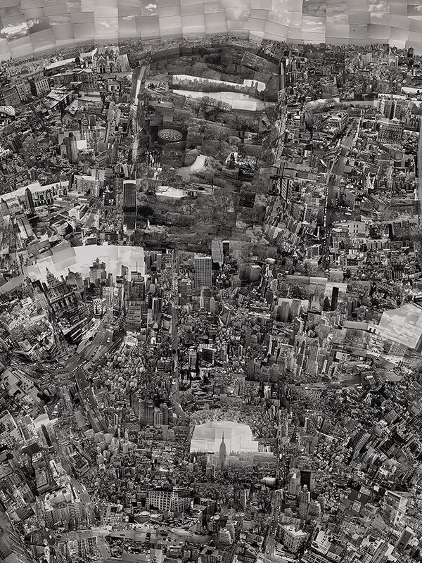
Sohei Nishino, Diorama Map New York, 2006. Photographs New York.
The truth of the reality and the memory of an experience are often in flux. Naturally, the space between the two is where photography forms a connective tissue which, ultimately, may not bridge the gap, but rather, as Sohei Nishino understands well, offers both perspective and conceptual scope for the ways memory and reality continually shape one another.
For nearly two decades, Nishino has explored these concepts in his series Diorama Maps. This project, first developed and conceptualized when the artist was a student at the Osaka University of the Arts in Japan, produces an uncanny reimagining of various cities and sites, drawing inspiration from the 18th century Japanese mapmaker Inō Tadataka. Produced from February through July of 2006, Diorama Map New York is a striking example of the photographer’s novel approach.
Sohei Nishino, Diorama Map New York, 2006. Photographs New York.
To produce these works, Nishino wanders his chosen city, typically over the course of several months, and produces an excess of images, frequently from a high angle perspective. Shooting 35mm film, he captures photographs of landmarks, atmospheric elements, and even residents on the street. After the initial imagine-making phrase, he then meticulously constructs massive collages using bits and pieces from numerous prints — often working with thousands of photographs for one project.
Once satisfied with his layout, Nishino photographs the final collage. The results are massive kaleidoscopic prints, sometimes up to seven feet wide. This impressive scale invites the viewer to inspect various details of the scene closely. Diorama Map New York is no different. At almost six feet tall, this colossal work depicts many iconic sites, including the Empire State Building, the Statue of Liberty, and Strawberry Fields in Central Park. However, as recognizable as this landscape is, Nishino’s maps aren’t necessarily geographically accurate; an intentional choice as the artist is more interested in conveying the sensory and experiential aspects of a place in gestalt.
…a trace of the way in which I walked through it, an embodiment of my awareness, a microcosm of the life and energy that comprises the city.
—Sohei Nishino
Nishino’s meticulous exploration in the studio is as essential as his walks through the cities. The artist notes, “I can say that each of these processes constitutes a part of my journey through the cities.” He has even been known to revisit source material years later to produce new Diorama Maps of cities explored previously — finding new ways to see them as his memories have developed with time. As the artist notes: “Photographs are not completed at the moment they are taken, but are completed in the process of recollecting the memories thereafter by confronting them again.”
In this sense, the Diorama Maps are as much representations of his own identity and spirit as they are dreamscapes or maps of cities. “I believe that what results from my confronting these enormous number of photographs and actualizing (them) again in the form of a map by integrating them, is my personal portrait, as well as my representation of the appearance of a specific city whose glimpse it has given me.”
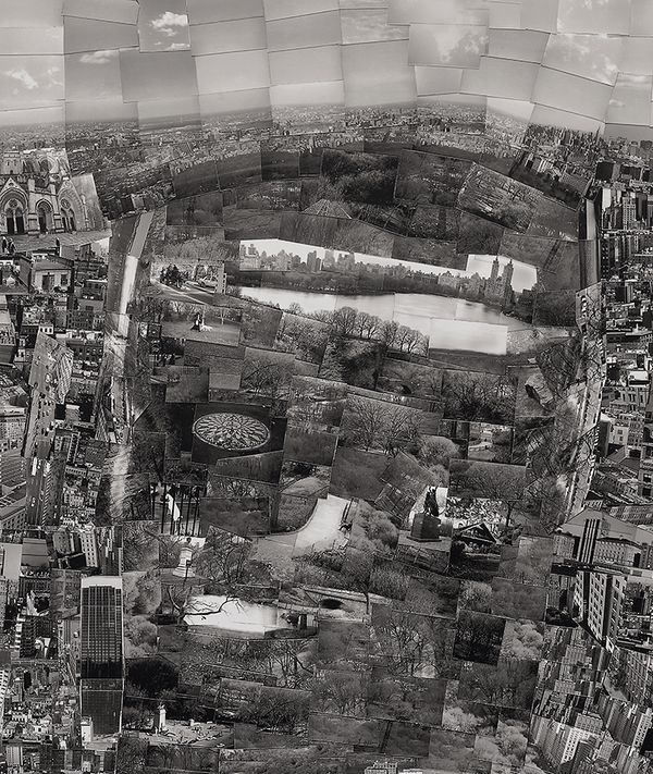
Sohei Nishino, Diorama Map New York (detail), 2006. Photographs New York.
The Japanese cartographer Inō Tadataka (1745–1818) is a key influence for Sohei Nishino and there is a shared sense of endurance in the process for both. Tadataka is recognized as the first person to employ modern scientific techniques to survey the geography of Japan, an act that led to the first definitive maps of the island nation, which were in use as late as 1924. Having been a successful businessman, Tadataka began the study of western astronomy, geography, and mathematics upon his retirement at the age of 49. In 1800, at the age of 55, Tadataka set out on an official survey of the country. Though he expected to complete the process in a few years, the project consumed the remaining 17 years of his life, requiring 3,736 days spent taking measurements alone.
Though Nishino’s Diorama Maps are not intended as geographical references for scientific study, we can get a sense of the patience in the process shared between Tadataka and Nishino. In an age of advanced technology, a cartographical process approached as art rather than science can impress much more by posing questions about society and culture rather than simply imparting facts. As Nishino says, “We have easy access to apps and Google maps, and so much information at hand about places before we visit. But in using these methods to reach somewhere quickly, and perhaps taking a shortcut, we sometimes lose a sense of time and a sense of ourselves. People forget about the process and focus on the final point. I want to show the sort of sensitivity that we used to have towards the journey.”
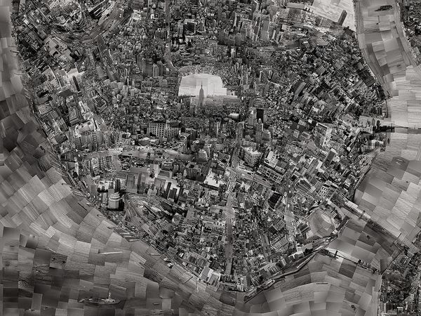
Sohei Nishino, Diorama Map New York (detail), 2006. Photographs New York.
Though geographical accuracy is of course considered in his process, Nishino often alters scale and occasionally repeats images from different vantage points. In this way, his maps represent the fallibility of our own memories of time and place — the works express a psychogeography as experienced by the artist, rather than a functional representation. They share with us how a place made him feel, act, and see — a way of understanding what a place can mean or how it can be perceived, rather than simply what is there.
Discover More from Photographs New York >
Auction /
Photographs, New York
Morning Session
4 April, 10am ET
Afternoon Session
4 April, 2pm ET
432 Park Avenue, New York (map)
Recommended Reading
The Look, Très Chic, The Wife and Her Lover: On one of Irving Penn's greatest masterpieces >
Have You Met the Man in the Polyester Suit? >
The Start of a Brilliant Career >